NorPlot - A Chart Plotter App for Norwegian Waters
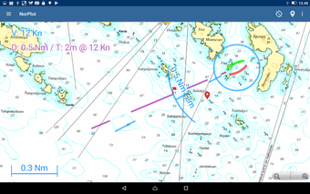
NorPlot is a free chart plotter app for Android users who want to navigate Norwegian waters with ease. The app uses map data from the Norwegian Mapping Authority open services to provide users with accurate and up-to-date information. The main focus of NorPlot is to make it easy for users to visualize their placement, distance, direction, and runtime to the finish.
In addition to these features, NorPlot also allows users to choose from different map types, add waypoints, navigate to items in the map or waypoints, measure distances in the map, and determine their boat's position in karflaten. The app is perfect for boaters who want to explore Norway's beautiful coastlines, fjords, and lakes.
It's worth noting that NorPlot will only work within Norway and won't be useful for those traveling outside the country. Overall, NorPlot is a reliable and useful app for boaters who want to navigate Norwegian waters with confidence.